El Niño is stifling hurricanes, but it could trigger winter tornadoes
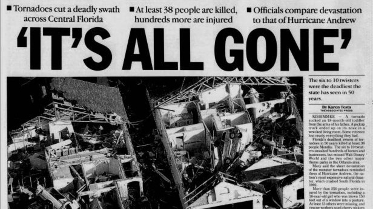
In the El Niño winter of 1998, tornadoes stole into Florida in the overnight hours of Feb. 22 with ruinous, murderous intent.
Read more Ballet and the Beasts takes the stage at new-look Montgomery Zoo
Newspaper articles talk of a baby sucked from his father’s arms into the darkness, a heroic fiancé who forced his girlfriend into the only safe space in their one-bedroom trailer before it disintegrated around them, and comparisons to Category 5 Hurricane Andrew but with less warning.
Forty-two people died, 250 were injured. The baby was found in a nearby body of water, the heroic fiancé in some grass near the twisted metal of the couple’s mobile home.
The coming months bring another El Niño winter, only different; stronger – the strongest possibly on record, and concerns are increasing about supercell thunderstorms vibrating with tornadic energy, flooding, late season freezes and a prolonged stretch of damp and cooler weather that could erode soil, increase plant disease and grown fungus on crops.
“People will notice the frequency of the rain,” said meteorologist Matt Volkmer, who was stationed in the National Weather Service’s Tallahassee office during the 1997-1998 El Niño. “We were working a strong thunderstorm every few days because they just kept coming.”
In the days following the 1998 tornadoes that included three rare 200-mph EF3s in Central Florida, El Niño seemed almost a novelty. Articles spelled it out phonetically (pronounced NEEN’yo), tildes over the “n” were largely absent, and descriptions were literal “El Nino means baby Jesus.”
Today, El Niño is water cooler conversation.
Volkmer, who is now science and operations officer at the NWS office in Melbourne, said people are more aware of the impacts of El Niño, possibly because of the so far radically serene 2026 hurricane season, which has had no hurricanes through Sept. 18.
But are they ready for something the world has not experienced in modern history?
“That’s what we are gearing up for,” Volkmer said.
El Niño is strongest during winter months
El Niño forms when east to west flowing trade winds slacken, allowing warm water that has been pushed toward Asia to slosh back east to South America.
That movement shifts rainfall and thunderstorm patterns, shoving the subtropical jet stream to more southern latitudes where it is in a better position to cut the tops of Atlantic hurricanes with strong scissoring winds called wind shear.
But El Niño is most powerful during the darkest days of the year when winter storms form on Florida’s west coast or in the Gulf and follow the subtropical jet stream east like cars on a rollercoaster.
Its more southerly position puts Florida, especially the Peninsula, in the direct path of the storms.
“This El Niño is probably going to be the strongest we’ll see in our lifetime so it’s not a surprise that the downstream affects could be record storminess,” said meteorologist Heather Zons, principal weather producer for The Weather Channel. “A lot of people go to Florida in the winter to escape the crappy weather and now they’ll be stuck with persistent cloud cover and storms.”
How much rain could Florida get this winter with El Niño?
This dry season, which typically runs mid-October through mid-May, the South Florida Water Management District is expecting up to three feet of rain.
That’s about two feet more than what’s normal for the 16-county region from Orlando through the Keys.
“The forecast is unprecedented; we have not seen a forecast like this,” said district chief engineer John Mitnik during a Sept. 10 meeting. “How it manifests itself and materializes, that’s what we’re waiting to see.”
By luck or a fluke or a bittersweet gift from Mother Nature, two years of persistent drought that continued through the summer wet season has left Florida in a better position to handle heavy rainfall through the winter months.
In the spring, water managers were praying for the hurricane season to bring a tropical system that would alleviate the parched conditions. Now, they are less eager as they try to make space in reservoirs and canals for the additional El Niño winter rainfall.
Lake Okeechobee’s water level was at 11.2 feet above sea level as of Sept. 9, according to the National Weather Service. That’s more than three feet below normal for this time of year and allows for it to swell without immediate harmful discharges to the Caloosahatchee and St. Lucie estuaries.
Statewide, the Florida Climate Center said an El Niño year brings between six and 10-plus inches of dry season rainfall above what’s normal. Central, southern and areas of the western Panhandle face the largest deluges, while North Florida and a strip from the Space Coast to Tampa Bay receive lower amounts but still above average.
“Other than building an ark, I’m assuming that you are figuring operations out for a potential of 37 inches of rain in the dry season,” said SFWMD Governing Board chairman Chauncey Goss during the Sept. 10 meeting.
Could heavy winter rains hurt farming in Florida?
The Florida Climate Center said the El Niño-sparked rainfall could be “critical to the recharge of surface and groundwater,” but could also cause problems for farmers.
“It will really slow us down if we get too much rain as far as getting the sugarcane out,” said Keith Wedgworth, president of the Western Palm Beach County Farm Bureau. “That’s part of farming I guess but I’d like to have at least one or two years without something devastating happening.”
Read more Inter Miami’s winless MLS streak stretches to four games with home tie against San Diego
Agriculture suffered statewide in the early months of 2026 with multi-day freezes. Farmers are now fighting infestations of pasture mealybug.
Cloudy skies also means less photosynthesis, which can slow a plant’s growth and make sugarcane less sweet. Soggy soil means more mildew on lettuce crops. Consistent rain can decrease sweet corn pollination.
“It will definitely have an impact,” said Ron Rice, University of Florida / IFAS extension department director in Palm Beach County. “The harvest can be disrupted. The plantings can be disrupted.”
Todd Thrift, a beef cattle specialist with UF, said more rain could benefit ranchers whose land is still suffering from dry conditions. In North Florida, ranchers plant winter forage in the fall, such as rye, to feed the cows through winter.
At the same time, an early frost that kills off the forage crop or extended periods of cold and wet can be hard on cattle.
“The type of cows we have in Florida are heat tolerant, not necessarily cold tolerant,” Thrift said. “Temperatures around freezing and five inches of rain can be detrimental.”
El Niño year tornadoes can be stronger, longer lasting
But it’s the El Niño-spurred tornadoes that are the most damaging and deadly overall.
In Central and South Florida, state data shows there is an 82% increase in tornadoes during El Niño years over La Niña years, and a 33% increase over years when the climate pattern is neutral. The six strongest El Niño years between 1950 and 2009 experienced 123 tornadoes in Central and South Florida.
“We’ve had strong El Niños and we know the impacts,” Volkmer said. “Increased storminess, increased severe weather, and the chances for tornadoes, and potentially long track tornadoes.”
The strength of El Niño is measured by how much warmer than normal sea surface temperatures are in the equatorial Pacific Ocean. The warmer the temperature, the stronger the event.
The 1997-1998 El Niño was the second strongest on record at the time with seas averaging 2.3 degrees Celsius (4.1 degrees Fahrenheit) above average. That was just below the 1982-1983 El Niño, which reached 2.4 degrees Celsius.
Forecasts for the current El Niño are for sea surface temperatures to reach 2.7 degrees Celsius (4.8 degrees Fahrenheit) warmer than normal.
“Everything is just indicating lots of intensification,” said Lindsey Long, a meteorologist on the Climate Prediction Center team that forecasts for El Niño.
A stronger El Niño typically means more potent impacts, including tornadoes
The tornado outbreak of 1998 began with a weak twister at 3:45 p.m. Sept. 22 that brought down some trees in Sumter County.
It escalated in the evening to an EF2 around 11 p.m. that struck near Daytona Beach and damaged or destroyed 600 structures along a shredding 8-mile path.
Then another tornado hit in Lake County closer to midnight. It sprinted into Orange County, rapidly intensified to an EF3, crushed a mobile home community in Winter Garden, killed three and injured 70.
Twelve people died in Seminole County when a second EF3 hit just after midnight. It then crossed into Seminole County where it killed one more at a fish camp on the St. John’s River.
But the deadliest tornado came near 1 a.m. to the City of Kissimmee, killing 25 people, including a 1-year-old boy, injuring 150 people and damaging or destroying more than 1,000 structures.
By dawn, 42 people were dead from seven tornadoes that struck Central Florida between 11 p.m. and 2:30 a.m.
“I would not be surprised if we see EF3s this winter,” Zons said. “It could be pretty significant, and a lot of people may not be expecting it. When you check the forecast on your phone, it doesn’t tell you the El Niño state.”
Kimberly Miller is a journalist for the USA TODAY NETWORK FLORIDA. She covers weather, the environment and critters as the Embracing Florida reporter. If you have news tips, please send them to [email protected]. You can get all of Florida’s best content directly in your inbox each weekday by signing up for the free newsletter, Florida TODAY, at palmbeachpost.com/newsletters.
This article originally appeared on Palm Beach Post: El Niño is stifling hurricanes, but it could trigger winter tornadoes
Read more Brady Tkachuk looks the part on Florida Panthers’ top line in preseason debut
Reporting by Kimberly Miller, USA TODAY NETWORK – Florida / Palm Beach Post
USA TODAY Network via Reuters Connect
Copyright Reuters or USA Today Network via Reuters Connect
This story was originally published September 21, 2026 at 5:06 AM.










Post Comment