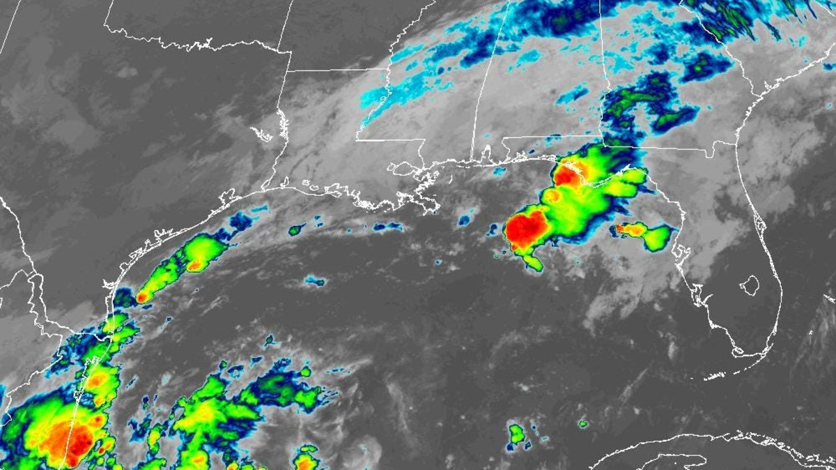
How strong will Gulf tropical disturbance get? See Florida risks, timing
If the so-far-quiet 2026 Atlantic hurricane season has made you complacent, it may be waking up.
Read more Hurricane center spikes chances of Gulf development to 70%
A disturbance in the Gulf has a high chance of developing this week and could become a tropical depression by the middle to later part of this week, according to the National Hurricane Center.
➤ Track all active storms
AccuWeather said a tropical storm is possible, and there’s even a low possibility of a hurricane.
➤ Weather alerts via text: Sign up to get updates about current storms and weather events by location
The next name on the Atlantic hurricane list is Isaias.
Shop Amazon for hurricane supplies
Regardless of strength, some rain and wind impacts can be expected in Florida from the system toward the end of the week and into the weekend.
As of Oct. 5, there have been no hurricanes and eight tropical storms in the Atlantic basin.
Here’s what is known at this time, although there is a great deal of uncertainty this far out.
Could we see a hurricane in the Gulf?
As of its 8 a.m. Oct. 5 seven-day forecast, the National Hurricane Center is saying a tropical depression is likely to form in the Gulf later this week.
“The most likely intensity is either a tropical depression or a tropical storm,” said Nick Arman, AccuWeather meteorologist of forecasting operations, via email Oct. 5.
“We currently believe there is a 15% chance of a hurricane strength storm from this area.”
Could tropical system in Gulf impact Florida?
“The eventual strength and track of any tropical system remain highly uncertain at this range, but it will be something to watch very closely over the coming days,” the National Weather Service Mobile said.
“Regardless of development, another period of widespread heavy rainfall appears increasingly possible, with gusty winds, dangerous surf, and coastal flooding also possible.”
When could Florida feel impacts from tropical system in Gulf?
For the United States, impacts would likely be from Friday (Oct. 9) through Sunday (Oct. 11) for the Gulf Coast, Arman said.
“Regardless of development, a surge of tropical moisture is likely to spread northward into much of the U.S. Gulf Coast which can lead to heavy rain and flooding late this week into the weekend.”
Where could tropical system go? Could there be a Florida landfall?
“With regards to where it might track, the most likely scenario is that it would track northward toward the northern Gulf Coast,” Arman said.
“However, there is still a wide variety of possible tracks depending on not only how quickly this development organizes, but also due to the influence of an upper-level low located over Texas.” Possibilities mentioned by Arman included:
- If this moves north quickly and organizes, it will likely track somewhere between far eastern Texas and the Florida Panhandle.
- If organization is slower, that would cause it to move farther westward toward the central Texas coast instead.
- There is also the possibility that the upper-low does not pull the development northward quick enough, causing it to meander in the Gulf before moving back southward toward Mexico and the Bay of Campeche instead.
“As of now (Oct. 5), the least likely areas for this to track are toward both coastal Texas (south of Houston) and central and southern Florida due to climatology.
“However, they can’t be ruled out completely at this point. We definitely think that Florida is at risk for tropical rain and wind impacts, especially the Florida Panhandle. The most likely impact would be heavy tropical rainfall.”
Is rapid intensification possible with Gulf system?
“The waters in the Gulf are certainly very warm, which can support rapid intensification,” Arman said, “however, the wind shear over much of the Gulf is likely to limit how quickly this area can organize and intensify.
“The most likely intensity is either a tropical depression or a tropical storm. We currently believe there is a 15% chance of a hurricane strength storm from this area.”
Read more Florida governor DeSantis visits future I-95 interchange at Oslo Road
National Hurricane Center tracking disturbance in Gulf showing potential for development
The National Hurricane Center’s 8 a.m. Oct. 5 advisory said a trough of low pressure in the southwestern Gulf of America is producing disorganized showers and thunderstorms.
Although environmental conditions appear to be marginally conducive, gradual development is becoming more likely, and a tropical depression is likely to form during the middle or latter portion of the week.
This system is expected to drift eastward over the next few days, before it turns northward.
- Formation chance through 48 hours: low, 30 percent
- Formation chance through 7 days: high, 70 percent
Flood watches, warnings, advisories issued for parts of Florida
Florida weather radar for Oct. 5, 2026
What do the colored, hatched areas on the NHC map mean?
The hatched areas on the National Hurricane Center’s tropical outlook map indicate “areas where a tropical cyclone – which could be a tropical depression, tropical storm or hurricane – could develop,” said National Hurricane Center Deputy Director Jamie Rhome.
➤ Hurricane Center is testing new cone: What’s changing the season
The colors make it visibly clear how likely a system could develop, with orange medium and red high. In 2026, the tropical outlook will use a gray X to indicate disturbances with a low chance for development.
The National Hurricane Center generally doesn’t issue tropical advisories until there is a named storm, but there is an exception.
“If a system is near land and there is potential for development, the National Hurricane Center won’t wait before it issues advisories, even if the system hasn’t become an actual storm. This gives residents time to prepare,” Rhome said.
What is a disturbance?
The National Hurricane Center’s tropical outlook map highlights “disturbances” in the Atlantic basin.
These are clusters of storms with some organization, but which don’t have a defined circulation typical of tropical cyclones.
➤ Ready or not, National Hurricane Center resumes daily tropical outlooks
If shown on the tropical outlook map in orange or red, forecasters are predicting the potential of those disturbances into developing as medium or high, respectively.
Disturbances shown on the map with a gray x have little to no chance for development. This is a change from prior years which indicated such disturbances in yellow.
When is hurricane season?
The Atlantic hurricane season runs from June 1 through Nov. 30.
Ninety-seven percent of tropical cyclone activity occurs during this time period, NOAA said.
➤ Hurricane Center testing new cone: What’s changing this season?
The Atlantic basin includes the northern Atlantic Ocean, Caribbean Sea and Gulf of America, as the Gulf of Mexico is now known in the U.S. per an order from President Trump. NOAA and the National Hurricane Center are now using Gulf of America on maps and in advisories.
Countdown clock to end of 2026 Atlantic hurricane season
Stay informed. Get weather alerts via text
What’s next?
We will continue to update our tropical weather coverage to bring you the most current information you need to protect your home and family.
Cheryl McCloud is a journalist for the USA TODAY Network-Florida’s service journalism Connect team. You can get all of Florida’s best content directly in your inbox each weekday day by signing up for the free newsletter, Florida TODAY, at naplesnews.com/newsletters.
This article originally appeared on Naples Daily News: How strong will Gulf tropical disturbance get? See Florida risks, timing
Our editors independently choose our recommendations. Some content is produced with paid support from a third party, however our editorial decisions remain independent. If you buy through our links, the USA TODAY Network may earn a commission. Prices and availability may change.
Read more Backlash to Trump hasn’t bolstered Florida Democrats’ voter registrations
Reporting by Cheryl McCloud, USA TODAY NETWORK – Florida / Naples Daily News
USA TODAY Network via Reuters Connect
Copyright Reuters or USA Today Network via Reuters Connect
This story was originally published October 5, 2026 at 11:34 AM.












Post Comment