Hurricane Center tracking system moving into area favoring development
It’s the middle of September and the good news continues in the tropics, although the National Hurricane Center is highlighting one area in the central Atlantic.
Read more More Than Half Of Americans Are Rethinking EVs
The system has a low chance for development over the next seven days, putting a second hurricane season record within reach.
Low chances doesn’t mean a zero chance for a tropical storm or hurricane. Weather experts always advise residents to remain prepared.
➤ Track all active storms
Shop Amazon for hurricane supplies
On Sept. 12, a 60-year-old record fell. The latest date for the first hurricane of the year had been Sept. 11, which has happened twice since 1966. Until this year.
If there are no hurricanes this year before Sept. 22, the 2026 season will break that record, as well.
Could we see no hurricanes in the Atlantic basin this year? If so, it will be only the third time in history.
➤ Weather alerts via text: Sign up to get updates about current storms and weather events by location
Here’s the latest advisory from the National Hurricane Center as of 2 a.m., Sept. 14:
Is there a hurricane coming to Florida?
No, but a trough of low pressure southeast of Bermuda is forecast to enter an area favorable for development later this week.
Could we see a tropical storm or hurricane near Florida in September?
Anything is possible, but chances are low, according to the National Hurricane Center.
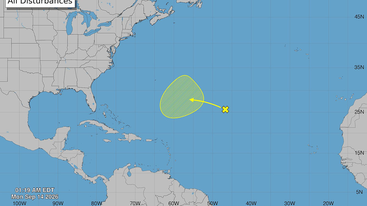
The National Hurricane Center was highlighting an area more than 1,000 miles southeast of Bermuda early Sept. 14, giving it a low chance for development over the next seven days, but it’s forecast to enter an area favorable for development later this week.
“Although there are no signs of immediate tropical development, non-tropical storms and other weather features drifting through or stalling in the region could produce one or two areas to monitor in the coming weeks,” according to AccuWeather.
AccuWeather forecasters increased chances for development of the system off Bermuda early Sept. 14, giving it a medium chance for development.
Forecasters were also highlighting an area to watch in the northern Gulf.
“If a tropical depression or storm forms close to the coast, residents may have little time to prepare for flooding rainfall, gusty winds and rough surf,” according to AccuWeather.
Atlantic breaks 60-year-old record
On average, the first hurricane in the Atlantic basin forms on Aug. 11, according to NOAA. The first major hurricane forms Sept. 1.
No hurricane has formed in the Atlantic Ocean so far in the 2026 season as of Sept. 14, setting a new record for the latest date for the formation of the season’s first hurricane.
As of Sept. 14, there have been five tropical storms.
“The Atlantic has never gone this late without a hurricane since modern satellite tracking began in 1966,” according to AccuWeather.
AccuWeather hurricane experts said a strengthening El Niño may limit opportunities for tropical storms to become hurricanes. Wind shear associated with El Niño helps prevent storms from developing or strengthening.
Could we see another hurricane record broken in 2026?
If no hurricane forms by Sept. 22, the 2026 season will officially break a record for the latest date a first hurricane has ever formed, according to AccuWeather.
Will 2026 be a year of no hurricanes?
If this year’s Atlantic season has no hurricanes by Nov. 30, it will be only the third time it’s happened and you have to go back to 1907 and 1914.
Of course, it is possible there were hurricanes, but records before the satellite era depended on observations on those nearby.
Since the satellite era began in 1966, there have been two occasions where we’ve seen two hurricanes in a season, in 1982 and 2013.
CSU predicting below-normal tropical activity through Sept. 15
In its two-week tropical forecast issued Sept. 2, Colorado State University said it was “strongly favoring below-normal activity during the next two weeks” (through Sept. 15), noting “there is very little signal for any potential TC (tropical cyclone) development in the next two weeks from any model.”
“Global model signals for TC development in the next two weeks are remarkably weak, given the next two weeks include the climatological peak of the season.”
Historically, major hurricanes develop in the eastern and central tropical Atlantic in early to mid-September, according to CSU.
Read more Victor DeRenzi, iconic maestro, bringing opera vision to Selby Gardens
The next two-week forecast from CSU will be released Sept. 16.
National Hurricane Center tracking one disturbance
There was one disturbance listed by the National Hurricane Center on its tropical outlook map as of 2 a.m. Sept. 14.
Central Subtropical Atlantic: A trough of low pressure located more than 1000 miles east-southeast of Bermuda continues to produce disorganized showers and thunderstorms.
Environmental conditions over the system are currently unfavorable for development due to strong upper-levelwinds. However, as the system moves west-northwestward across the central part of the Subtropical Atlantic, it is forecast to enter a more conducive environment for gradual development by the middle to latter portion of this week.
- Formation chance through 48 hours: low, near 0 percent
- Formation chance through 7 days: low, 30 percent
There are two tropical waves:
- A central Atlantic tropical wave is along 47W, south of 18N, moving westward at 17 to 23 mph.
- Another central Atlantic tropical wave is along 50W, south of 17N, moving westward at near 17 mph.
What do the colored, hatched areas on the NHC map mean?
The hatched areas on the National Hurricane Center’s tropical outlook map indicate “areas where a tropical cyclone – which could be a tropical depression, tropical storm or hurricane – could develop,” said National Hurricane Center Deputy Director Jamie Rhome.
➤ Hurricane Center is testing new cone: What’s changing the season
The colors make it visibly clear how likely a system could develop, with orange medium and red high. In 2026, the tropical outlook will use a gray X to indicate disturbances with a low chance for development.
The National Hurricane Center generally doesn’t issue tropical advisories until there is a named storm, but there is an exception.
“If a system is near land and there is potential for development, the National Hurricane Center won’t wait before it issues advisories, even if the system hasn’t become an actual storm. This gives residents time to prepare,” Rhome said.
What is a disturbance?
The National Hurricane Center’s tropical outlook map highlights “disturbances” in the Atlantic basin.
These are clusters of storms with some organization, but which don’t have a defined circulation typical of tropical cyclones.
➤ Ready or not, National Hurricane Center resumes daily tropical outlooks
If shown on the tropical outlook map in orange or red, forecasters are predicting the potential of those disturbances into developing as medium or high, respectively.
Disturbances shown on the map with a gray x have little to no chance for development. This is a change from prior years which indicated such disturbances in yellow.
What is a tropical wave?
“Tropical waves are clusters of showers and thunderstorms that act as the seedlings for many tropical storms throughout the Atlantic season,” said Alex DaSilva, AccuWeather lead hurricane expert, via email.
“There are about 60 tropical waves that move across the Atlantic each year, and roughly 10 percent to 15 percent of them develop into a tropical system. That’s about one in seven.
“Tropical waves are important because they contribute to about 80 percent of all major hurricanes.”
When is hurricane season?
The Atlantic hurricane season runs from June 1 through Nov. 30.
Ninety-seven percent of tropical cyclone activity occurs during this time period, NOAA said.
➤ Hurricane Center testing new cone: What’s changing this season?
The Atlantic basin includes the northern Atlantic Ocean, Caribbean Sea and Gulf of America, as the Gulf of Mexico is now known in the U.S. per an order from President Trump. NOAA and the National Hurricane Center are now using Gulf of America on its maps and in its advisories.
Countdown clock to end of 2026 Atlantic hurricane season
How many tropical storms, hurricanes are in a typical season?
The 30-year average, from 1991 to 2020, is for 14 named storms, seven hurricanes and three major hurricanes.
Florida weather radar for Sept. 14, 2026
Weather watches and warnings issued in Florida
When is the peak of hurricane season?
The peak of the season was Sept. 10, with the most activity happening between mid-August and mid-October, according to the Hurricane Center.
What are names for 2026 Atlantic hurricane season?
Here are the names for the 2026 Atlantic hurricane season and how to pronounce them:
- Arthur: Tropical Storm Arthur formed June 17, 2026
- Bertha: Tropical Storm Bertha formed July 20, 2026
- Cristobal: Tropical Storm Cristobal formed Aug. 12
- Dolly: Tropical Storm Dolly formed Aug. 27
- Edouard: Tropical Storm Edouard formed Sept. 1
- Fay, fay: (sixth-named storm historically forms Aug. 29; first hurricane by Aug. 11; and first major hurricane Sept. 1)
- Gonzalo, gohn-SAH-loh
- Hanna, HAN-uh
- Isaias, ees-ah-EE-ahs
- Josephine, JOH-seh-feen
- Kyle, KY-ull
- Leah, LEE-ah
- Marco, MAR-koe
- Nana, NA-na
- Omar, OH-mar
- Paulette, pawl-LET
- Rene, re-NAY
- Sally, SAL-ee
- Teddy, TEHD-ee
- Vicky, VIH-kee
- Wilfred, WILL-fred
Interactive map: See how many hurricanes, tropical storms have passed near your home
Stay informed. Get weather alerts via text
What’s next?
We will continue to update our tropical weather coverage to bring you the most current information you need to protect your home and family.
Cheryl McCloud is a journalist for the USA TODAY Network-Florida’s service journalism Connect team. You can get all of Florida’s best content directly in your inbox each weekday day by signing up for the free newsletter, Florida TODAY, at https://naplesnews.com/newsletters.
This article originally appeared on Naples Daily News: Hurricane Center tracking system moving into area favoring development
Our editors independently choose our recommendations. Some content is produced with paid support from a third party, however our editorial decisions remain independent. If you buy through our links, the USA TODAY Network may earn a commission. Prices and availability may change.
Read more Analysis-Bitcoin’s late summer rally set to face off against the Fed, Congress
Reporting by Cheryl McCloud, USA TODAY NETWORK – Florida / Naples Daily News
USA TODAY Network via Reuters Connect
Copyright Reuters or USA Today Network via Reuters Connect
This story was originally published September 14, 2026 at 6:48 AM.










Post Comment